Curiosity Rover’s Mission Update: Sols 4355-4356.
NASA’s Curiosity Rover is making strides again on Mars. After 13 years on the Red Planet, it recently completed an ambitious two-sol (Mars-day) operation. This latest sequence focused on intricate rock and soil analyses within Gale Crater, with remote imaging and close-up observations planned across the Martian terrain. As Curiosity’s team celebrates a weekend of successful navigation and data capture, this mission update highlights both Curiosity’s resilience and the cutting-edge science it continues to deliver.
Exploring Gale Crater: An Ongoing Mission
Curiosity has been exploring Gale Crater since landing in 2012, a mission with one primary question: could Mars have supported life? Gale Crater’s unique geological layers may hold clues to ancient water activity, making it the perfect site for examining Mars’ distant past.
Curiosity’s tools allow it to analyze everything from surface textures to the planet’s atmosphere. In this latest sol plan, the rover is exploring specific features, including:
- Rock Formations: Bedrock and fractured surfaces are of particular interest for chemical analyses.
- Atmospheric Insights: Observing the Martian atmosphere, as seasonal variations provide insight into its composition.
Curiosity’s latest findings contribute to our understanding of Mars’ history and inform potential future missions, including those with human explorers.
The Science Behind Sols 4355-4356
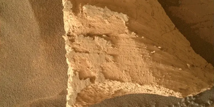
In the two-sol plan, Curiosity’s scientific instruments were hard at work. During the first sol, the rover focused on a bedrock surface nicknamed “Epidote Peak” and a nearby crushed rock area, “Milly’s Foot Path.” The Advanced Planetary X-ray Spectrometer (APXS) was used on Epidote Peak, taking readings during the chilly Martian night when its sensors function best.
Key Observations and Imaging
The imaging schedule for these sols included a series of complex camera and sensor activities. The steps of this session included:
- ChemCam Analysis: ChemCam used its Laser-Induced Breakdown Spectroscopy (LIBS) on a layered bedrock formation, “Albanita Meadows,” allowing scientists to examine the distribution of minerals within the layers.
- Remote Imaging: Mastcam and Navcam cameras provided panoramic and close-up images, capturing everything from distant buttes to specific rock formations within Gale Crater.
Data Collection Highlights:
- 138 Images Captured: Mastcam took a total of 138 images, including a 44-frame stereo mosaic of the distant Wilkerson Butte and surrounding areas, providing high-definition images for analysis.
- 64 MAHLI Photos: The Mars Hand Lens Imager (MAHLI) captured 64 images of Epidote Peak and Milly’s Foot Path under consistent shadow, enhancing contrast and detail.
Table: Key Findings and Observations from Sols 4355-4356
| Observation | Instrument Used | Area on Mars | Purpose of Observation |
|---|---|---|---|
| Epidote Peak | APXS, MAHLI | Gale Crater bedrock | Analyze mineral content and assess geological history |
| Albanita Meadows | ChemCam | Layered bedrock | Mineral mapping and LIBS analysis on rock layers |
| Gediz Vallis Ridge | Mastcam | Distance imaging area | Capture images of Martian ridges and geological features |
| Milly’s Foot Path | MAHLI | Crushed rock sample | Document rock textures and rover interaction with surface |
A Glimpse into Curiosity’s Drive Plan
After completing the imaging sequence, Curiosity’s team directed the rover to move approximately 34 meters (112 feet) northwest. This planned drive brought Curiosity closer to a dark-toned band in the sulfate unit—a formation thought to hold clues to Mars’ wet history. The sulfate-rich terrain often suggests water presence in Mars’ distant past, making it a critical area of study.
Beyond Rocks: Atmospheric and Remote Observations
While Curiosity’s immediate work focuses on Mars’ surface, observing the atmosphere is equally important. During this mission update, Curiosity’s team conducted a series of atmospheric tests to understand seasonal patterns.
- Mastcam Tau Observation: This observation measured the amount of dust and other particulates in the atmosphere, providing valuable data for understanding Mars’ seasonal dust cycles.
- Autonomous AEGIS System: In addition to direct imaging, Curiosity deployed AEGIS, a targeting software that automatically identifies potential targets for the rover’s ChemCam, increasing efficiency in data collection.
- Navcam Sky and Terrain Imaging: Navcam collected data on sky conditions and terrain changes, enabling scientists to monitor environmental shifts over time.
The Journey Continues: Curiosity’s Contribution to Future Mars Missions
Curiosity’s continued functionality speaks to NASA’s engineering achievements and mission planning. With over 13 years of data collection, Curiosity has contributed significantly to planetary science and has kept the public engaged with captivating images and discoveries from Mars.
This latest mission update also underscores Curiosity’s value in laying groundwork for future missions. Here are some ways the data aids future exploration:
- Enhanced Geological Mapping: By analyzing rock layers and mineral distribution, scientists gain a clearer picture of Mars’ ancient environment.
- Mission Planning: The data from Curiosity’s experiences—navigating rugged terrain, handling dust storms, and seasonal temperature changes—provides insights for planning future rover and crewed missions.
Curiosity’s journey exemplifies both resilience and exploration, helping answer some of humanity’s biggest questions about our planetary neighbor. The achievements of Sols 4355-4356 show that even after a decade, Curiosity’s mission is far from over, and its findings continue to deepen our understanding of Mars.
Sources: THX News, Britannica, LiveScience & NASA.


